Lake Okeechobee/Kissimmee Chain of Lakes Update
March 2025 FloridAgriculture eNewsletter
Lake Okeechobee recession is continuing due to Recovery Operations, as well as increasing evapotranspiration and water supply deliveries.
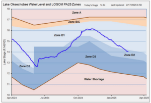
As of February 17th, 2025, the lake stage is 14.04 feet, which is down 0.14 feet over the last week, and 0.56 feet over the last month. The U.S. Army Corps of Engineers (Corps) and the South Florida Water management District (District) are maintaining Lake Okeechobee System Operating Manual (LOSOM) Recovery Operations where LOSOM release guidance is up to 2,100 cubic feet per second (cfs) at the S-79 structure west into the Caloosahatchee River, 1,400 cfs total east to the St. Lucie River, and max practical releases to increase flow to the south.
Average flows for the last week from Lake Okeechobee to the east and west have averaged 500 and 1,500 cfs, respectively, towards the downstream targets with 1,300 cfs going to the Everglades Agricultural Area (EAA) for water supply, and 1,400 cfs to the stormwater treatment areas (STAs). The lake stage is currently in Zone D2 (see graphic below), where LOSOM guidance without recovery operations being implemented would be up to 750 cfs at S-79 and zero east to the St. Lucie with maximum beneficial flows south.
Discharges made south from the Upper Kissimmee Lakes are being made to reach the June 1st low pool targets. Lake Kissimmee is below schedule with decreasing releases to the river channel.

Figure 1. Lake Okeechobee stage as of 17 February 2025.
The Stormwater Treatment Areas (STAs) are exclusively treating water from Lake Okeechobee. The latest 28-day STA inflow concentrations in the Eastern Restoration Strategies flow path range from 158 to 191 parts per billion (ppb) of phosphorus, with outflows from the STAs ranging from 18 to 26 ppb. Inflow concentrations in the Central flow path range from 83 to 101 ppb, with outflows ranging from 12 t0 17 ppb. The Western flow path, STA 5/6, has had no inflow for the last several months.
Most STA cells, or sections within the whole STA, are near their target stages, but many flow ways still have stressed vegetation conditions. There are operational restrictions in place for most of the STAs for vegetation management and/or construction activities.
Water Conservation Area (WCA) stages are decreasing, and some northern areas have water near ground surface (see depth graphic below). WCA-1 is at and receding with its schedule with no outflows to WCA-2A or to tide. WCA-2A is 0.97 feet above schedule with only water supply deliveries being made to Broward County. WCA-3A is 0.80 feet below schedule with large areas in the south below historical averages, but still above ground surface.
Everglades National Park is continuing to receive water into the dry season based on Tamiami Trail Flow Formula (TTFF) targets. WCA-3A is below schedule and the TTFF calls for 981 cfs from WCA-3A. The S-12C and S-12D structures and the S-333 structures are open and delivering 986 cfs into the park. Hydrologic connectivity within Shark River and Taylor Sloughs has diminished over the past two months, however, depths remain conducive for water flow. The S-356 structure is off, with diminished seepage and lower canal stages. The S-332D and S-200 are pumping water into the detention areas as needed to control South Dade canal stages. The gate from the Frog Pond detention area into Taylor Slough is open. Florida Bay flow and salinity metrics remain well outside of all harm thresholds.
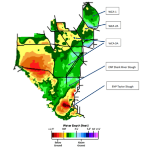
Figure 2. Water Conservation Area water levels as of 17 February 2025.
The post Lake Okeechobee/Kissimmee Chain of Lakes Update appeared first on Florida Farm Bureau.

